If there is one hike on Oahu you must do before you die, climb Kuli'ou'ou Ridge to Pu'u O Kona. The loop trail is by far the best hike I've done, edging Pu'u Manamana by a hair. Shanoah, Chase, and I hiked the Kuli'ou'ou Ridge state trail last month. We proceeded past the marker where the state trail ends and the trek to Pu'u O Kona began; however, the first day we did the trail the weather was extremely clear. You can see that hike by visiting this link:
http://kaleolancaster.blogspot.com/2008/05/may-8-2008-kuliouou-ridge.html. Pu'u O Kona could be seen in the distance, and the views along the ridge would have been incredible, but I had to work that day, and our hike was cut short. Today was a holiday, and I was off from work. I asked a few people to come with me, but everyone turned me down, except Shanoah. We packed two meals, an extra liter of water, and started our hike into Kuli'ou'ou Valley in hopes of finding the ridge that scaled Pu'u O Kona from the west. After about a mile into the valley we gave up on finding the side trail that led to the ridge. With time wasted, we walked back to the Kuli'ou'ou Ridge state trailhead and began the two-and-a-half mile journey up the switchbacks in the blazing 2pm sun. There were a lot of people hiking the state trail as well. As we approached the end mark we could see that the whole mountain was completely socked in with clouds. Thinking back on how clear it was the last time we hiked this trail irritated me; I wanted to get some photos. I put my camera in my bag, and Shanoah and I blazed our way through the hairy sections we hiked once before, this time with no hesitation. We reached the point where we had turned around the last time and sat down for a lunch break. It was really cold, and our vision could see what was ahead of us for only about 100 feet or so, yet it never rained. After lunch we proceeded on the ridge to the summit of Pu'u O Kona. The ridge began to narrow, and the drops on the right side of the trail were phenonmenal. It's a shame the clouds masked the views; the shots I snapped would have been priceless. We encountered many sections where we thought about turning around. One section I remember was a landslide we had to walk across. I tested the frailness of the trail with my foot, and the top of that landslide will someday give way, making the trail impossible to cross for future hikers. The landslide section sloped upward, and it was at this part that the trail had become about a foot across. I still can't believe we racked up the balls to cross it. Another memorable section was a 20-foot rope connected to a lauhala tree branch at the top of a steep incline. Shanoah had realized what the rope had been anchored to when he reached the top, and he said if he knew it was anchored to a weak tree branch, he wouldn't have gone up the slope. That rope section also had a huge sheer drop on the right side. I almost thought about turning around before Shanoah tugged at the rope, but we made it past the rope section and could see Pu'u O Kona, shrouded in the Ko'olau mist. We reached the broad, grassy summit of Pu'u O Kona (elevation: 2,200 ft.), rested for a bit in the clouds that hampered our views, and descended down the west ridge of Kuli'ou'ou. The trek back down was lengthy, still dangerous and narrow, and steep. I'm glad we didn't find the trailhead to come up the west ridge; we probably would have turned around because the steep climb up would have been really difficult. After four-and-a-half hours of hiking we finally reached the culdesac at Kala'au Place and headed back home, satisfied, yet aching from the seven miles we hiked. I actually took some photos that came out really nice. Shanoah's one lucky bastard. Most of the photos are of him.
 Looking back at the Kuli'ou'ou Ridge state trail end mark (top right). There are some people on the unimproved trail in the middle of the picture.
 This is where we turned around last time. Shanoah, leading the way through uluhe ferns and Clidemia shrubs.

 Thimbleberry. I ate a few along the way.

The ridge swung left toward Pu'u O Kona.


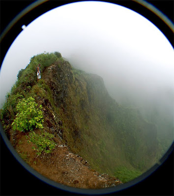 Fish eye perspective of a huge drop.
 "No fish eye" perspective of the huge drop.

 This section was extremely dangerous. We had to walk over this landslide.
 Shanoah, running up the narrow landslide ridge.
 How's the silhouette of that near-vertical ridge?! Nuts!
 The rope section. Notice the drop on the right side.
 Drops galore.
 There's Pu'u O Kona.
 Last stretch is pretty overgrown.
 The start of the west ridge descent.

 Narrow dike section.


 Right below the clouds.
 Long way to go.

 Ever see the backside of Diamond Head?

 This part of the descent went through an ohi'a tree garden. Probably the most ohi'a trees I've ever seen.
 Bug.
Bug.

Out of the clouds.

Views:
 Rabbit Island through the clouds.
 Halemaumau Ridge, Hawaii Loa Ridge, Wiliwilinui Ridge, and Diamond Head in the distance.
Plants:

Ohi'a.

 Looking back at the Kuli'ou'ou Ridge state trail end mark (top right). There are some people on the unimproved trail in the middle of the picture.
  This is where we turned around last time. Shanoah, leading the way through uluhe ferns and Clidemia shrubs.
 Thimbleberry. I ate a few along the way.


 Fish eye perspective of a huge drop.
  "No fish eye" perspective of the huge drop.
 This section was extremely dangerous. We had to walk over this landslide.
  Shanoah, running up the narrow landslide ridge.
  How's the silhouette of that near-vertical ridge?! Nuts!
 The rope section. Notice the drop on the right side.
  Drops galore.
  There's Pu'u O Kona.
  Last stretch is pretty overgrown.
  The start of the west ridge descent.
 Narrow dike section.

 Right below the clouds.
  Long way to go.
 Ever see the backside of Diamond Head?
 This part of the descent went through an ohi'a tree garden. Probably the most ohi'a trees I've ever seen.
  Bug.
Bug. 

 Rabbit Island through the clouds.
  Halemaumau Ridge, Hawaii Loa Ridge, Wiliwilinui Ridge, and Diamond Head in the distance.

1 comment:
That looks really cool. I ran back about 1/2 mile past the "End of Trail" sign but didn't have a chance to do the whole thing since I was with a few people that would not have that. I was thinking of taking my dog on it but he is not as experienced as I would like and I'm not sure how he would fair on some of the ropes. Great blog. I plan on looking at a lot of your trips!
Post a Comment