For some reason, I can’t escape dirt roads. The past three hikes all began on dirt roads, and quite frankly, I’m sick of it. I hope Halawa Ridge doesn’t welcome me with dirt-road-hike number five on Sunday. I just might quit hiking altogether. Well, maybe not quit, but I will be pissed.
I shunted off from Moanalua Valley Park at around 9:20am. I reached the Kulana’ahana trailhead in just under an hour. From there I crossed the stream, passed a stream gauging station on the left, and reached a junction. The left junction was the down trail for the physically demanding Godek-Juskulski loop that Daniel and I did in the beginning of May 2009. I took the right junction.
The trail is very well-trodden and easy to follow. A couple of confusing stream crossings could lead a novice hiker astray, but as long as there are ribbons around, follow it. The well-trodden trail is also very muddy in multiple areas. When crossing the stream, one has to be careful because of the slippery boulders that aid the hiker across without getting their feet wet. I fell around three times, so use caution.
After the twenty-fifth crossing, a sign comes into view stating that the trail beyond is no longer maintained. From this point on is where the hardest part of the hike begins. The trail then climbs up a short, steep ridge to the Moanalua Valley saddle. Along the uluhe clad ridge were some nice ohi’a trees and views back into Moanalua Valley. Although steep, the ridge was not narrow or perilous. To the right, a high waterfall can be seen. The enticing waterfall would be my destination on the return from the summit.
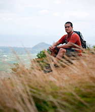
As I neared the top around 11:30am, two signs came into view: one stating that it was the end of the trail and that I shouldn’t go beyond the sign (oookay?), and another stating that a ledge existed, and if I were to stand on that ledge, it might break off and I would fall and die: fair claim. I headed past the signs. Ahead were views of Haiku Valley, Kaneohe Bay, Mokapu Point, and the snaky H-3 freeway. To the right along the summit were the top outs of the Haiku Stairs (Stairway to Heaven) and Pu’u Keahi a Kahoe. To the left was an extremely steep trail leading to the terminus of Red Hill/Godek-Jaskulski Ridge; beyond that terminus was the apex of Halawa Ridge. I sat to eat my lunch, made a few calls on my cell phone, snapped some photos and took some video, and then headed down the ridge I came up to go in search of the waterfall.
At the bottom of the ridge, I turned left, upstream. I followed a faint trail with old ribbons tied to trees and branches, guiding me further upstream. Remnants of an old airplane that crashed long ago lay scattered in bushes and in the stream. Soon the trail disappeared, so I had to submit to walking directly in the stream, boulder hopping and climbing.
After about fifteen minutes, I reached the waterfall. It was merely a trickle on this day, but from the looks of it, the waterfall would be beautiful after a long, stiff rain. Height-wise, the waterfall is huge; I’d say well over 100 feet. A shallow, uninviting pool at the bottom harbored some baby o’opu, a fresh water fish that is edible, but one I’ve never tried before. I again snapped some photos and took some video and headed back.
The total mileage of this hike was about eleven miles because of the short side route I took to the waterfall. The side route to the waterfall is not very far at all, and it is easy to get to. Completing the stream hike to summit to the waterfall and back took me a little over five hours. The view at the saddle is one that should be prized, for no other state trail can overlook Haiku Valley and the H-3. The only other ways to get the view would be hiking Red Hill Ridge and Halawa Ridge, both of which are very long and taxing. The Kulana’ahane Trail is a more rational choice, but one thing is for sure: the trail is not “brand new.” It’s been hiked for decades.
 One hour in, two-and-a-half miles from Moanalua Valley Park is the Kulana'ahana trailhead.


 View of the waterfall from the steep ridge.
 The steep ridge to the summit saddle.
 Looking back into Moanalua Valley from the saddle, proving once again that I was very, very far away from my car.


 The waterfall.
Video: