
Poamoho Ridge is a gem among all Oahu state trails. It's located in one of the most desolate areas on Oahu in the the Ewa Forest Reserve. It's short, it's easy, and it tops out at arguably the best view on the island. It also is home to many native Hawaiian plants. Poamoho Ridge is a graded trail, meaning it is cut below the crest of the ridge, making for relatively easy walking all the way to the Ko'olau summit without feeling much elevation gain. To hike the Poamoho trail, a permit must obtained from the Department of Land and Natural Resources. The permit allows access to a six mile dirt road and three locked gates. The gate combinations are supposedly changed every week; the combos are listed on the permit for the week that is chosen. The road, used primarily by hunters, passes a large ranch and heads deep into the Ko'olau mountain range. As of July 2011, the road is in very good shape. A two-wheel drive vehicle could make it, however, a particular section near the end of the road may be tricky when it's wet.
Our day started at 7am at the top of California Avenue in Wahiawa. From there we staged two vehicles, jumped in Brian Bautista's truck, and was shuttled by his dad all the way to the Poamoho Ridge trailhead just before the military gate on Pa'ala'a Uka Pupukea Road. The weather was overcast and surprisingly cool for a summer day in July. The tradewinds were blowing, and the mountains looked ominous with wispy, silk-like clouds basking the peaks along the Ko'olau summit.
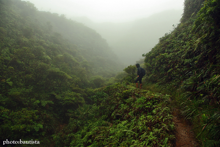
At around 8am, we reached the official Poamoho trailhead and parted ways with Brian's dad who then drove the truck back out. The trail was muddy but very groomed. En route we passed two hunters and several of their hunting dogs. Superb views of the Waianae Mountain Range and the Mokuleia coastline could be seen. We paralleled Poamoho Gulch to the south and could see Poamoho Stream flowing audibly. At a certain point, the rain started to come down hard, making for even muddier conditions all the way to the summit. I was envious at the sight of Nate, Christina, and Daniel donning rain gear; Brian and I were without jackets. At around 10:40am, we reached the summit, only to be completely socked in with no chance of a view of the windward side. It was cold and very wet.
After a short break at the Poamoho summit, we turned right along the Ko'olau Summit Trail and hiked through the muddiest terrain I have ever hiked in. Skirting mudholes were impossible, so walking in the mud, at times shin high, was the norm. The rain was in full force, and the trail turned into a flowing river, with shin high waterfalls trickling at our feet as we gained and loss elevation. After about twenty minutes of walking we reached the Poamoho Cabin, doors unlocked. I was surprised at the condition of the shelter. It was clean, cozy, and harbored everything needed to survive. Water catchment behind the cabin flowed underneath the cabin in a PVC pipe with a spigot at its end. Inside the cabin at the far wall were four bunks complete with mattress pads, sleeping bags, and pillows. Large plastic boxes in the cabin contained food (rice, bread, trail mix, peanut butter and jelly, etc.), cooking supplies (pans, pots, portable stoves, etc), and clothing. There was a bench, folding chairs, a radio, a deck of playing cards, and even mouthwash. By mountain standards, the cabin was more like a hotel, far from rundown, but far from what Paris Hilton would be satisfied with. A log book near the window contained writings of previous visits by other hikers. Lots of stories of rat poo and cockroaches, but we didn't see any. The last entry was around May 28-30, 2011, Memorial Day Weekend. We jotted our names down, took a half hour break to wait out the rain, and headed back out on the summit trail at about noon.
A few short sections of trail along the muddy and vegetated leeward side soon made its way to a small meadow. The trail then switched to the windward side. The initial windward section is unbelievably clear, and it would be safe to say that you could actually ride a mountain bike on it, though I don't recommend it because there are large drops to the windward that could prove fatal if someone fell. Still in the clouds with an occasional downpour, we trekked the windward section all way to Pu'u Pauao. It was at Pu'u Pauao where the clouds finally lifted and we were able to see the amazing views over looking Punalu'u Valley and Kahana Valley. I pointed out to the others the section of trail along Pauao Ridge that Daniel and I helped clear several weeks prior. I double-ribboned the intersection of Pauao Ridge and the KST, and we then headed for the final windward stretch to the top of the Schofield-Waikane trail.
In relation from Poamoho to Pauao, the stretch between Pauao and Schofield-Waikane was far more overgrown. Uluhe, palms, and clidemia choked the trail, making for slow progress to the Schofield-Waikane junction. We also encountered three large washouts, all of which were the only dangerous sections along the entire hike. The first washout was a steep descent over crumbly and slippery rock. The second was a narrow walk on loose dirt. The third washout was a minor, narrow hump over unstable ground.
At 2:30pm, we finally reached the top of the Schofield-Waikane trail and had lunch. As happy as we were to make it to top of the Schofield-Waikane trail, we still had seven more miles of hiking to reach the top of Wahiawa Heights. We started our descent down Schofield-Waikane at 3pm at a brisk pace. The walk down Schofield-Waikane was uneventful except for moments of heavy rain that kept us cool the whole way. At 4:50pm, we reached the East Range military road, and were back at the top of California Avenue at 5:50pm. Total distance: a little over twelve miles. Total time: nine hours and forty minutes.
To do Poamoho Ridge, visit the following website:
Na Ala Hele - Poamoho Ridge Trail
To get access for Schofield-Waikane, visit the following website:
Na Ala Hele - Schofield-Waikane Trail
To see past write-ups along the Schofield-Waikane trail, click on the following links:
Schofield-Waikane Trail - July 5th, 2009
Kaukonahua Stream (North Fork) - March 28th, 2010


On the Poamoho trail. (photo: B. Bautista)

Looking into Poamoho Gulch and stream. (photo: B. Bautista)

photo: B. Bautista

Looking toward Kaena Point. (photo: D. Napoleon)


photo: N. Rubio
In the clouds. (photo: B. Bautista)

Plaque at the Poamoho summit indiacting the mileage to other points along the Ko'olau Summit Trail. (photo: D. Napoleon)

Cold, windy, rainy, and in the clouds at the Poamoho summit. (photo: B. Bautista)

This is how the view from the Poamoho summit should look on a clear day. This photo was taken in November 2010. (photo: B. Bautista)

Heading south along the KST. (photo: N. Rubio)

The Poamoho Cabin. (photo: N. Rubio)

On the Poamoho Cabin porch. (photo: B. Bautista)

Poamoho Cabin log book.

On the leeward side of the KST. (photo: N. Rubio)

photo: D. Napoleon

photo: N. Rubio

photo: D. Napoleon

photo: B. Bautista

photo: D. Napoleon

photo: N. Rubio


photo: B. Bautista

photo: N. Rubio


What a view. (photo: B. Bautista)

photo: B. Bautista


photo: N. Rubio

At the Schofield-Waikane terminus. (photo: B. Bautista)

Looking toward the Waianae Mountain Range and our long way back down to Wahiawa. (photo: B. Bautista)
Nate Rubio's version:


3 comments:
Thanks for the post. Good memories for me.
To avoid the vehicle shuttle, there is a way to do this hike starting and ending at the end of California Ave. It involves going cross-country using a segment of the Wahiawa Hills trail then connecting to the Poamoho access road about a half hour from the Poamoho trailhead. The cross country section from California Ave to the PAR takes about an hour, give or take. Hunters use this with some regularity.
HTMC used this route for a members-only loop hike back in the late 90s early 2000s.
Hi, we've read about that route on Dayle's site but just haven't had the time to explore it. It's a loop we eventually plan to do amongst the many other hikes yet to be done. So much 'aina, so little time.
Aloha,
Brian
Another amazing post! Would you mind writing a review of the trail and uploading some photos of it here: https://lookintohawaii.com/hawaii/48959/poamoho-trail-activities-oahu-wahiawa-hi
Post a Comment